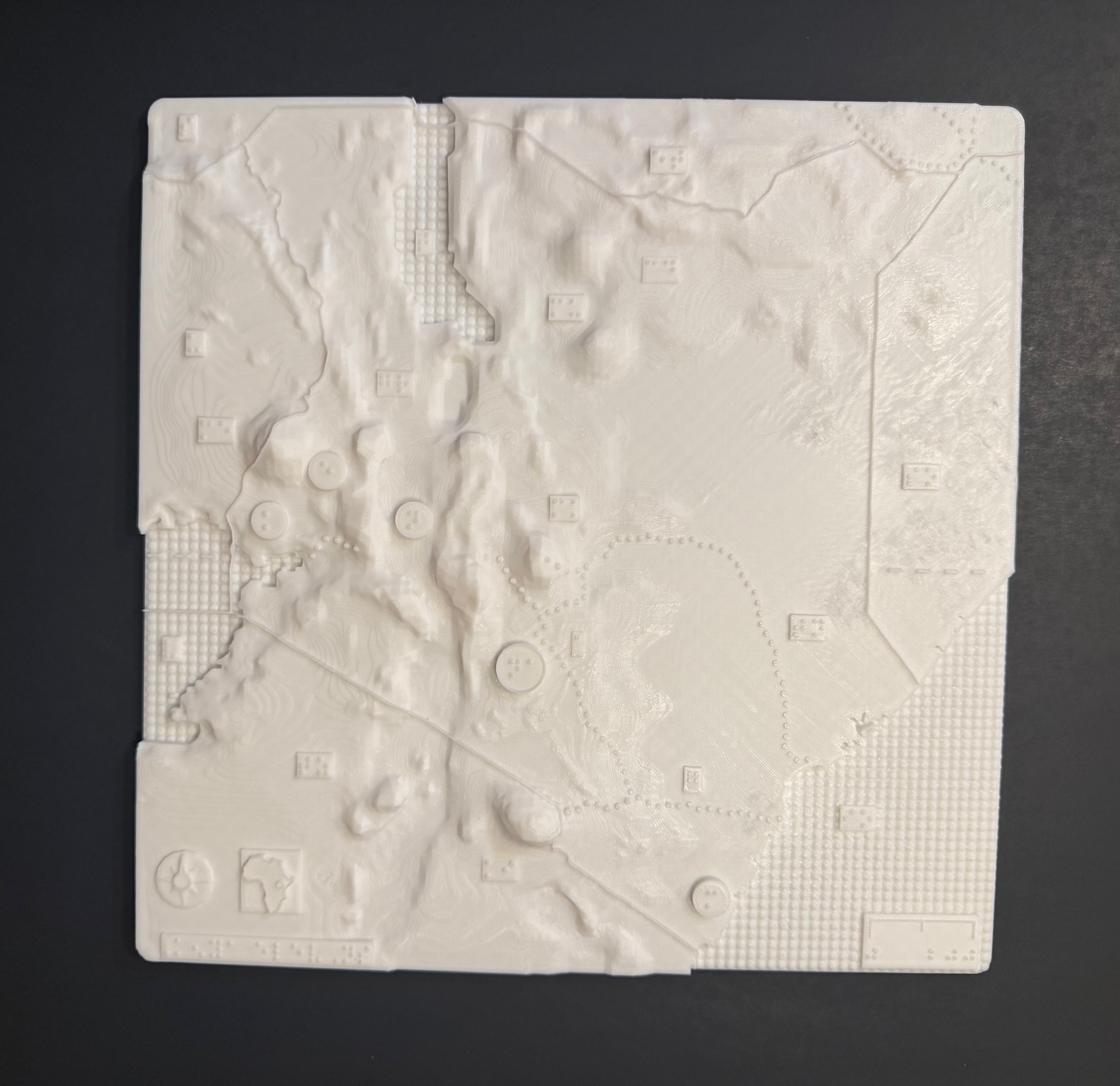
Tactile maps are, by design, three-dimensional, as they use raised surfaces to make a two-dimensional map touchable. However, traditional tactile maps elevate features just enough for them to be discernible by touch, while 3D maps go further by utilizing height and depth to convey richer, more intuitive information. This makes >3D tactile maps more effective and accessible in many contexts.

The above 3-D map shows the elevations of Kenya with braille labels, made in collaboration with the Clovernook Center for the Blind & Visually Impaired
How Do 2D Maps Work?
2D tactile maps represent spatial information on a flat surface, such as paper or plastic, with raised features to convey a simplified version of the three-dimensional environment. Think of them as traditional flat maps enhanced with tactile elements like raised lines and braille labels. For instance, roads, rivers, and building outlines are marked with tactile lines or patterns, while text is provided in braille.
More complex information, such as elevation or population density, can be depicted using different tactile patterns like dots or textured lines. Some advanced braille embossers even allow variations in line height to mimic color differences, but these do not offer true three-dimensional representation. In a way, these maps could be considered “2.5D” rather than truly three-dimensional.
What is a 3D tactile Map?
A 3D map goes beyond tactile markings to create a miniature, physical representation of an environment. For example, instead of using a pattern to indicate the height of a mountain, a 3D map includes a scaled model of the mountain itself. Indoor maps might feature small steps to represent staircases, while city or campus maps might include miniature buildings. These physical structures offer a more realistic tactile experience, allowing users to better understand the environment.
What Do 3D Maps Add to 2D Representation?
3D maps can be easier to interpret and memorize, offering a more realistic and intuitive experience. Consider the difference between a line drawing and a photograph of the same scene. While a photograph provides a clearer sense of depth, it is still two-dimensional and not tactile. A blind person would require significant adaptations to interpret a raised photograph, but they can readily understand a 3D model of the same environment.
More Intuitive Representations
Some features are inherently easier to recognize in 3D. For instance, a tactile pattern representing a mountain on a 2D map must be explained and memorized. However, on a 3D map, a miniature mountain needs little explanation—it is self-evident. Similarly, in a 3D park map, miniature roads, benches, and stairs can be included. While these elements can still be identified in a map key, users are likely to recognize and remember them more quickly when they resemble real-world objects.
Vertical Variety and Space Efficiency
One advantage of 3D maps is their ability to extend vertically, making better use of space. For instance, a city’s population could be represented by the height of a cylinder, which is easier to understand and takes up less space than a larger, flat symbol on a 2D map. This leaves more room for additional features or keeps the map less cluttered.
City maps in 3D can even resemble skylines, where the shape and height of buildings provide meaningful information. Instead of a simple square to indicate a building on a 2D map, a 3D map can feature a scaled structure, offering more detail in the same amount of space.
Durability
While 2D maps are often made of paper or thin plastic, 3D maps are typically crafted from sturdier materials like PLA, resin, or metal. These materials make 3D maps more durable and easier to handle, especially when standing or moving. A 3D map is less likely to tear or wear out compared to a traditional tactile map.
Disadvantages
Despite their benefits, 3D maps are not without drawbacks. One significant limitation is cost. Producing a single 3D map can take 5–10 hours on a standard 3D printer and requires a significant amount of material. In contrast, a 2D tactile map can be printed on paper in under a minute. However, it’s worth noting that while a 3D printer is less expensive than a braille embosser, the production process for 3D maps is more time-consuming.
Purchasing 3D maps can also be costly, so it’s important to consider the intended use. For example, a simple walking map of a residential area might be more practical as a 2D map. However, a complex floor plan for a hotel or conference venue could benefit from the added depth and clarity of a 3D map.
Conclusion
While 3D maps are becoming more common, they are still less widespread than 2D tactile maps. Fewer organizations produce them, and there is less information available on making them accessible. Although this article does not cover map accessibility in depth, it’s an important aspect to consider. Ultimately, the effectiveness of a map depends on how well it serves its intended users. Simply creating a map—whether 2D or 3D—does not guarantee it will meet their needs.
If you have any questions about 3D maps, or would like us to design your own tactile map, please contact us, and let’s discuss it.


No comments! Be the first commenter?